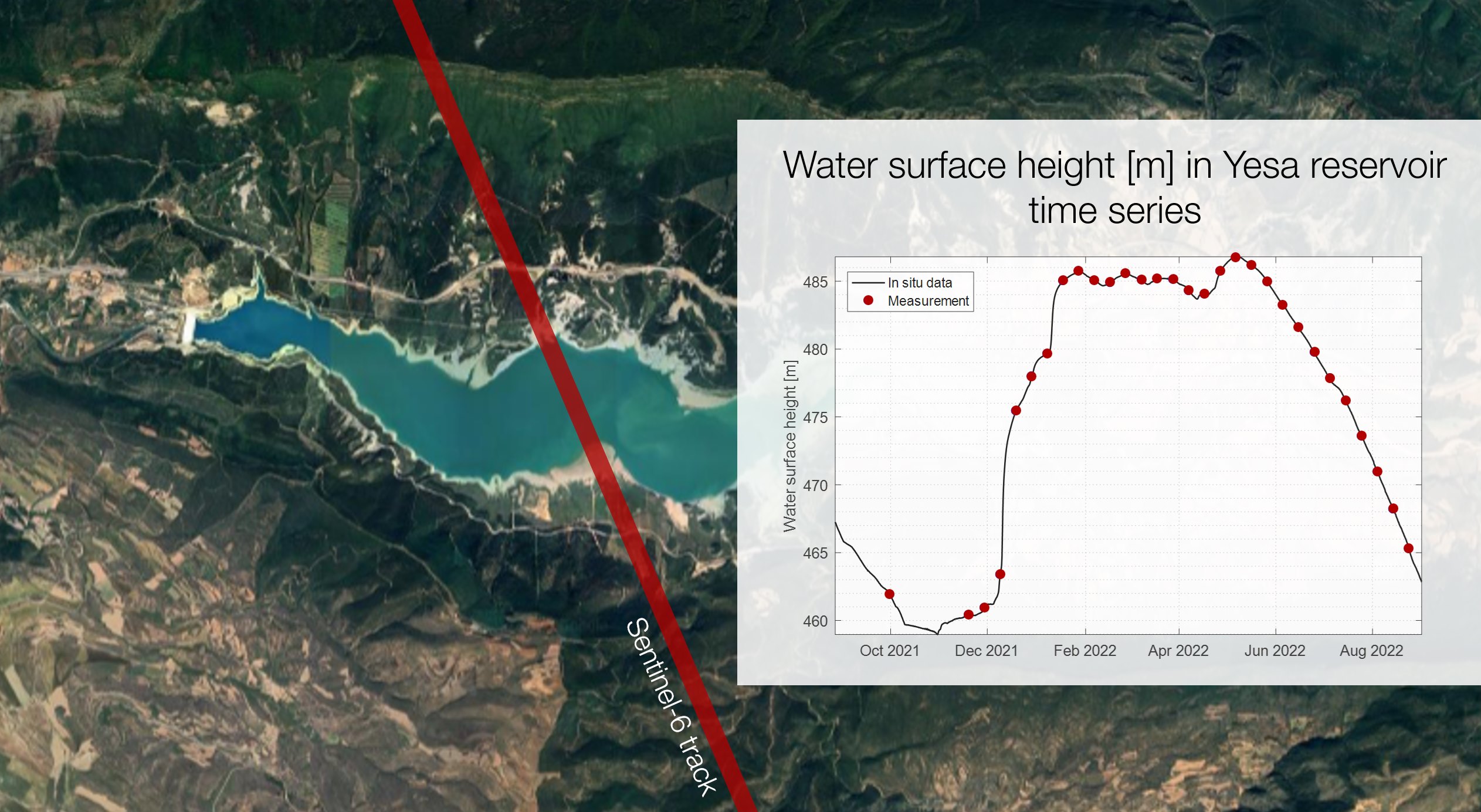
 Comparison of FF-SAR and in situ water level measurements in Yesa reservoir. © isardSAT
The VALERIA project assesses different case studies involving Sentinel-6 measurements over inland targets to demonstrate how Fully-Focussed SAR (FF-SAR) processing allows the retrieval of Water Surface Height (water level) and water extent measurements from specular water bodies. The study has been conducted over small and medium-sized reservoirs located along the ground tracks of Sentinel-6 satellite in the Iberian Peninsula (especially within Ebre river basin), and show a certain seasonal water extent variability. These reservoirs are monitored by the Ebro Hydrographic Confederation, who provides in situ data to validate the developed algorithms.
The FF-SAR algorithm significantly reduces the along track resolution, approaching the theoretical limits of around 0.5 m – far greater compared to the approximately 300 m resolution provided by operational processors based on Unfocussed SAR algorithms. It has been demonstrated that the improved resolution of the FF-SAR method allows to enhance the accuracy when measuring the water level and the spatial distribution of the selected targets.
isardSAT proposed this initiative to the Sentinel-6 Validation Team, as an activity to demonstrate Fully-Focussed SAR capabilities over inland waters.
Project presentations
2023
- Gómez Olivé, A., Gibert, F., Garcia-Mondéjar, A., and McKeown, C. ‘Water extent estimation over inland targets using FF-SAR data’. Hydrospace, 27 November – 1 December, Lisbon, Portugal. See abstract here (page 212).
- Gibert, F., Molina, R., Gómez-Olivé, A., Domingo, X., Escorihuela, M.J., Garcia-Mondéjar, A., Roca, M. ‘Water Surface Level Measurements Over Inland Targets With FFSAR’. Hydrospace, 27 November – 1 December, Lisbon, Portugal. See abstract here (page 235).
- Gómez Olivé, A., Gibert, F., Garcia-Mondéjar, A., and McKeown, C.: Water Extent Measurements with Sentinel-6 Fully - Focussed SAR data, EGU General Assembly 2023, Vienna, Austria, 24–28 Apr 2023, EGU23-448. See abstract here.
- Molina Burgués, R., Gibert, F., Gómez, A., Garcia-Mondéjar, A., and Roca i Aparici, M.: Water Surface Height Measurements with Sentinel-6 Fully-Focussed SAR Over Inland Targets, EGU General Assembly 2023, Vienna, Austria, 24–28 Apr 2023, EGU23-449, https://doi.org/10.5194/egusphere-egu23-449, 2023.
2022
- Ferran Gibert, Adrià Gómez-Olivé, Charlie McKeown, Robert Molina, Albert Garcia-Mondéjar. ’Water Elevation and Water Extent measurements with Sentinel-6A radar altimeter Fully-Focussed SAR data”. 2022 Ocean Surface Topography Science Team Meeting. Venice, Italy, 31 October – 4 November 2022. See abstract here.
- Ferran Gibert “Water surface height estimates over small lakes using FF-SAR”. Sentinel-6 Validation Team Meeting #4, 11-13 July 2022 (online). See presentation here.